There were many interesting thunderstorms during this year season in Slovakia but the biggest one hit the western part of the country in the late evening hours on August 10th. The large Mesoscale Convective System (MCS) developed over Slovenia close to the sharp temperature boundary and very quickly moved to the north with the speed above 25 m/s (Animation 1).
Animation 1 – MSG IR10.8 satellite image (limited to -20 st.C), equivalent temperature in 925 hPa and geopotential in 500 hPa level. Note the extensive anvil of the storm system.
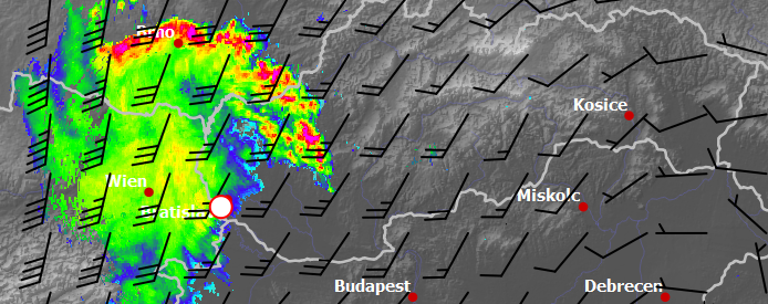
As can be seen from precipitation radar data (Animation 2), the line of thunderstorm cells is shaped like an archer’s bow as crossing the Slovakia. It is sign of strong cold air outflow and such kind of radar echoes has been named “bow echoes”. These systems typically produce severe straight-line winds and causing major damage along their paths as it was the case. This bow echo is very extensive (more than 200 km) and the wind gusts reached 25-30 m/s across southwestern part of Slovakia and in neighbouring countries (eswd.eu/cgi-bin/eswd.cgi).
The huge shelf cloud with drifted dust illuminated by the city lights are followed by the little rain and moderate electrical activity (Animation 3).
Animation 2 – Precipitation radar composite with deep layer wind shear. Values higher than 10-15 m/s favor long-lived and fast-moving storm systems. The white circle marks position where timelapse photography was made (animation 3).
Animation 3 – Timelapse photography of storm passing over Bratislava. Single images are captured once in 5 sec. with exposure time 1 sec. Animation is 75x faster than the reality.
0 Comments Leave a comment
Comments are closed.