IBL Software Engineering is delighted to announce its significant contribution to the first successful stratospheric test flight of BAE Prismatic’s PHASA-35, a solar-powered Uncrewed Air System. This remarkable achievement was made possible through a collaborative effort with the Met Office, whose expert scientists and meteorologists provided crucial data and analysis.
The PHASA-35, developed and designed by Prismatic in Alton, Hampshire, has the wingspan of an airliner and is intended for surveillance and communications use. Remarkably, it has the capability to remain airborne for several months, potentially up to a year. The aircraft, which weighs just 150kg – equivalent to a standard motorbike, climbed above 66,000ft during the test flight. The high-altitude flight, which lasted 24 hours, took off from Spaceport America in New Mexico.
One of the major challenges faced during this project was the influence of weather, turbulence, icing, and small gusts on these extremely fragile and ultra-lightweight air vehicles. Even in areas known for clear skies and calm conditions, the take-off and recovery of these delicate aircraft can be challenging. IBL Software Engineering’s sophisticated software, provided as a managed service, played a pivotal role in overcoming these challenges, bringing to life the high-resolution forecast data provided by the Met Office. This collaboration was instrumental in the planning process, ensuring the successful execution of this groundbreaking voyage.
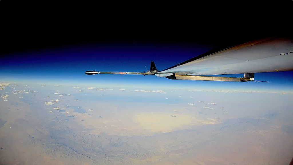
Source: BAE Systems Prismatic
Michal Weis, Chief Executive Director at IBL Software Engineering, expressed immense pride in the company’s involvement. “The successful stratospheric test flight of the PHASA-35 is a testament to the power of collaboration and innovation,” Michal said. “Our software, in conjunction with the Met Office’s expertise and high-resolution forecast data, provided an essential advantage in the planning and execution of this remarkable voyage.”
IBL’s innovative product, Online Weather, was crucial in visualizing the weather data and analysis for the PHASA-35 project and in making the weather data actionable for the flight operations team, seamlessly integrating with mission planning tools. Leveraging the expertise of Met Office science and technical specialists, the team was able to understand where and when the platform could be used around the world within the operating boundaries for future test and operational flights. This collaboration underscores IBL’s commitment to delivering high-quality, innovative solutions that drive the success of complex projects like the PHASA-35.
IBL Software Engineering looks forward to continued collaboration with the Met Office, BAE, and Prismatic on this innovative project. The company is gratified to see the added value delivered through this partnership and is eager to contribute to future successes, including Prismatic’s aim to break altitude records with more aircraft and continued flight trials.
Source: BAE Systems Prismatic PHASA-35 Flight Trial Vlog
For more information on the development of the PHASA-35 project, visit the Prismatic Website, where the Met Office continues to provide expert support and analysis.
About IBL
IBL Software Engineering, a world-leading company with over 40 years of experience, specializes in providing turn-key meteorological systems for meteorological services worldwide. At IBL, we firmly believe in the immense significance of weather information for individuals and businesses. We understand that this information must be presented in the right format, context, and timing. Continually innovating in meteorological processing, we develop tools and products for meteorological users worldwide. Our solutions empower users to grasp the essential elements, analyze them, and act upon them, thereby consistently enhancing efficiency and the value delivered to the public.
For more information, visit www.iblsoft.com
Enquiries: sales@iblsoft.com / +421 2 326 621 21

The idea for the eGAFOR Project arose from the need to provide faster and better weather services to general aviation users. Currently general aviation users in Europe have very different and un-harmonized meteorological products available, primarily due to a large number of countries, different forecasting areas, un-harmonized forecasting methods and different meteorological products. On the other hand, general aviation is the most sensitive and most vulnerable part of aviation to hazardous weather phenomena.
The goal of the eGAFOR Project is to provide general aviation pilots with easily understandable meteorological information on the condition of a particular route, and it is based on the co-operation of aviation meteorological service providers in Central and Southeastern Europe.
Due to the Project goal – easier informing and flight preparation and better connectivity between countries – the Innovation and Networks Executive Agency (INEA), the European Commission body, has recognized the eGAFOR Project and is co-financing it with 85% through the CEF Transport Call 2016.
The result of the Project will be the eGAFOR forecast – a uniform graphical forecast of meteorological phenomena hazardous for aviation on the general aviation route network that will be available to users through this website upon completion of the Project.
The countries participating in the Project are Bosnia and Herzegovina, Croatia, Hungary, Montenegro, Romania, Serbia, Slovakia and Slovenia. IBL Software Engineering participates as an industrial partner.
The eGAFOR Project started on 03.07.2017 and will end on 31.12.2020.
More information can be found on the page http://egafor.eu.
IBL User Group Meeting will take place on 07th – 10th October 2019 in Innsbruck, Austria.
Like last year, we plan to have four days of meeting, during which we will present recent developments as well as planned new functionalities in the Visual Weather, Aero Weather, Online Weather, Numeric Weather and Moving Weather products. A significant part of the meeting will be devoted to discussions and work shops which are a source of great inspiration.

Book a time and come to visit us at the Meteorological Technology World Expo, the world’s largest meteorological event. This year’s event will take place between June 5th -7th in Palexpo, Geneva, Switzerland. You can find us at the stand no. 4020, we will be glad to meet you there to talk about weather data processing or to present you what is our software capable to do with a really big datasets.
Come to visit us at Meteorological Technology World Expo 2018 in Amsterdam between 09 – 11 October 2018! We will be there at stand no. 10005 to show our software helping to handle really big data sets, or just stop by to talk about actionable weather data processing.
IBL User Group Meeting will take place on 24th – 27th September 2018 in Bucharest, Romania.
The aim of User Group Meeting is to expand cooperation and communication in the community of IBL product users. A significant part of the meeting will be devoted to discussions and work shops which are a source of great inspiration. Program will cover Visual Weather, Aero Weather and Online Weather products.
 Another Nor’easter is heading for US East Coast (3/7/2018)
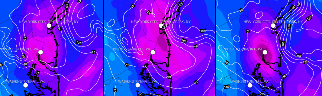
Meteorologists expect second winter storm in span of a week but they are not sure where it will hit…it seems from GFS model precipitation forecast consistency that the most affected areas will be around Philadelphia and New York City. These areas could be covered by 10-30 cm of wet snow during next night combined with wind gusts up to 100 km/h. However, Canadian cold pool is pretty warm these days thus authorities need to be prepared for heavy coastal rain and floods also.
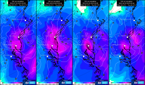
Multiview display animation of typical meteorological fields necessary to recognize blizzard threat – upper level and surface level pressure fields, 850 hPa temperature, 700 hPa relative humidity, surface wind and precipitation.
Detailed view of 24h precipitation forecast consistency for the East Coast area over the last 4 days, isolines of zero temperature height above sea level (ASL) are included. The most affected area has 0 deg.C level between 300 and 500 m ASL, thus intensity is crucial factor for precipitation type on the surface.
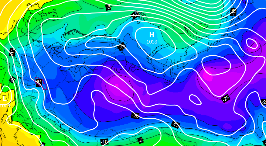 Massive cold outbreak is heading to Europe (2/21/2018)
This winter season was the 20th warmest on record in Slovakia (until February 15th), however, every tail has a sting. The European land is cooled down after all and mild maritime air is streamed deeply to the Arctic regions at the same time. As a response, strong anticyclone circulation over Scandinavia and Barents Sea is developed. Consequently, there is flowing of continental air over the Europe around this huge weather system and this chilled air mass can even reach the British Isles. This type of pressure and temperature field typically leads to even more unusual circulation patterns thus many meteorologists and weather enthusiasts closely watch to every new numerical model outputs.
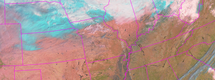 GOES-R new images (2/9/2018)
First images from the brand new GOES-16 are here! Combined into so-called “Near natural” RGB composite, it can distinguish ice from water clouds during daily hours, thus we can take a look at the North America continent snow coverage (light turquoise colours without movement). The animation below shows how quickly is snow vanishing over Kansas and Missouri states on February 8th, when maximal temperatures raised up from -2 to roughly +15 dg.C in last two days.
IBL User Group Meeting will take place on 2nd – 5th October 2017 in Split, Croatia
The aim of the meeting is to expand cooperation and communication in the community of IBL product users where we will cover Visual Weather, Aero Weather, Moving Weather Online Weather, Numeric Weather and Climate Weather products.